Teacher Portal:
Watersheds
Investigation 1 – Concept Day
ZERO-IN

The italicized font represents information to be shared orally or physically completed with the students at this time.
The non-italicized font represents additional information included supporting the teacher’s understanding of the content being introduced within the CELL.
ASK WHY
Explain to students that they are part of a watershed, and everything they do on the surface affects the water in their creeks and rivers, thus affecting the water they drink and the water for all living creatures within them.
BRANCH OUT
Explain to students that watershed coordinators monitor industrial pollution, habitat destruction, and excessive diversion within local watersheds. They then develop and lead efforts to keep the local watershed and its ecosystems healthy for years to come.
PRINT IT
Use your browser to download a printable PDF as a help during the slide presentation and to make additional notes. In your browser, go to File > Print and then choose to save as PDF.
NAVIGATE IT
Once the slide presentation is launched
- use your left and right arrows to advance or go back in the slide presentation, and
- hover your mouse over the left edge of the presentation to get a view of the thumbnails for all the slides so that you can quickly move anywhere in the presentation.
- Click HERE to launch the slide presentation for the CELL.
SHARE IT

SLIDE WSHEDS-1-1
In this Investigation, we wish to introduce students to the concept of watersheds. Every one of us lives in a watershed. That is, if we spill a glass of water onto the grass, that glass of water will eventually make its way to the ocean. Which ocean depends on the watershed in which we live.
______________________________________________

SLIDE WSHEDS-1-2
- As stated in this slide: a watershed is the area of land where all of the water that is under it or drains off of it goes into the same place. This most often is ultimately one of the world’s oceans.
- Continents are above sea level, sometimes as much as 6,000 meters plus above sea level on the highest mountain peaks. On the other hand, water always seeks to follow the force of gravity and will continue to do so until reaching sea level. This means that all water on the continents is on a continuous journey to the oceans.
- Since the continents are not flat and water never spontaneously flows uphill against gravity, the Earth is spotted with basins of water that will all flow toward specific outlets, typically rivers and deltas, to the ocean. These basins can be geographically rather small or enormous and are called watersheds. There are over 2,000 watersheds in the continental US alone.
- This slide uses a funnel as an analogy for a watershed. Regardless of where water is poured into the funnel, it will ultimately follow gravity and leave the funnel through the same stem.
______________________________________________

SLIDE WSHEDS-1-3
Note: This is an animated slide. More information is included beneath the US map. You may wish to practice this animation prior to the presentation to the class.
- In the previous slide, we mentioned that watersheds could be enormous. The Mississippi basin (highlighted in yellow on this slide) is one such watershed. Water collected from as far northwest as Montana and Canada and as far northeast as New York State eventually drains into the Mississippi delta on the Louisiana coast and into the Gulf of Mexico.
- Notice that there are numerous large rivers contained within the Mississippi basin. In fact, a number of smaller, but still quite large, basins conjoin to create the Mississippi basin.
Note: An animation click exposes the underlying basins. The underlying graphic is also shown below:
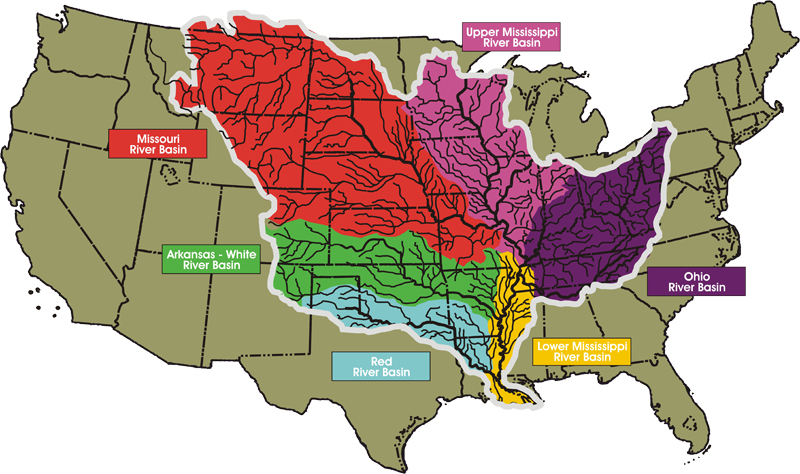
- Each of the 6 sub-basins shown is associated with a major river. The Upper and Lower Mississippi River basin drain streams and small rivers directly into the Mississippi. The Missouri basin extends up into Canada while the watershed draining into the Ohio River reaches as far a New York. The Arkansas-White and the Red basins drain into those large rivers. Ultimately, all of this water flows into the Gulf of Mexico, mainly through the Mississippi delta.
- With a surface area covering over 3 million m2, the Mississippi is the fourth largest watershed in the world after the Amazon, Congo, and Nile River watersheds. The Amazon basin is by far the largest basin in the world, draining the landmass of nearly the entirety of the South American continent, over 6 million m2.
______________________________________________

SLIDE WSHEDS-1-4
- The Great Continental Divide runs through North, Central, and South America. The rain that falls to the west of the Divide will end up in the Pacific Ocean. The rain that falls to the east of the Divide will end up entering the Atlantic Ocean. To get to the Atlantic, the water may need to pass first through the Arctic Ocean to the north or Hudson Bay and the Labrador Sea to get there… but it will get there.
______________________________________________

SLIDE WSHEDS-1-5
- The Great Continental Divide is not the only continental divide in North America. It is simply the demarcation between the Pacific and Atlantic runoff. On the Atlantic side of North America, various divides determine if water will drain directly into the Atlantic Ocean or through other coastal water on the way.
- We can also see from this slide that there are continental divides on every continent on planet Earth. In South America, the Great Continental Divide that runs south from Alaska continues to the southern tip of Chile. Water to the east drains into the Atlantic Ocean, water to the west drains into the Pacific Ocean through the massive Amazon watershed.
- Notice the many countries that drain into the Indian Ocean.
- Note that in this map China, Japan, Indonesia, and many other countries drain into the Pacific Ocean as does western North, Central, and South America.
- Much of Russia, Canada, and Greenland drain directly into the great Arctic Ocean.
______________________________________________

SLIDE WSHEDS-1-6
- As mentioned earlier, smaller watersheds often conjoin to form larger drainage systems. This slide depicts the Chesapeake Bay watershed, which extends as far north as south-central New York State and drains much of Pennsylvania, Maryland, Washington DC, part of Delaware, northern and central Virginia, and a small part of eastern West Virginia. All of the water drained from this vast area eventually reaches the Chesapeake Bay before moving south and into the Atlantic Ocean.
- Notice the Delaware, Maryland, Virginia coastal peninsula. Rain falling near the coast drains directly into the Atlantic Ocean. Yet water from the same rainstorm, falling only meters to the west may drain west into the Chesapeake Bay and then south through the Bay (about 300km) before finally arriving at the Atlantic Ocean!
______________________________________________

SLIDE WSHEDS-1-7
Note: This slide depicts the water cycle, a concept that LabLearner students should be quite familiar with but is worth reviewing in this context. While we could start anywhere in the cycle, let’s begin with precipitation at the upper right.
- Precipitation comes in the form of rain, sleet, and snow, depending on temperature and elevation. As seen in the slide, precipitation that lands at high elevations follow contours of the land by gravity, forming and following creeks and streams to lower elevations, eventually reaching rivers that are fed by many such small arteries of running water.
- Moving toward the foreground of this slide, we see surface runoff near the center. When precipitation falls on relatively flat land, it nonetheless follows the slightest incline and moves across its surface. It accumulates and moves through any depression and can forcibly dig into the land surface causing erosion. We will discuss water erosion of this sort more in Investigation 2. Eventually, surface runoff arrives at streams and rivers.
- If surface runoff is not fast enough, much of it disappears by infiltration into groundwater as shown at the lower right. The rate at which infiltration occurs, of course, depends on the land surface and soil type. Rich, organic soil, such as on a forest floor, absorbs water very quickly. Once absorbed, the water still follows the forces of gravity and continues to move underground, eventually arriving at rivers or flowing out of the watershed underground.
- Compacted clay-based soil will not permit substantial percolation. Paved parking lots and roadways prevent percolation entirely and thus can cause major runoff issues in urban areas.
- Turning to the upward movement of the water cycle, water moves from the liquid to gas state by both evaporation and transpiration. Evaporation occurs wherever water is found at the surface. Plants in the watershed absorb groundwater through their root system for use in the photosynthesis reaction. However, some of the water that is taken up by plants into the billions of leaves and blades of grass in a watershed is lost by them and into the atmosphere in the process of transpiration.
- Water leaving the surface of the watershed by transpiration and evaporation ascends into the atmosphere (left side of the slide) as it is heated by the sun. Higher in the atmosphere, where temperatures cool, water vapor condenses to form clouds, which eventually fill and become saturated. This leads to precipitation and our discussion of the water cycle is complete.
- It is important to note that precipitation is the source of all water on land! Without precipitation, the land would be absolutely dry and incapable of sustaining any type of life. Without precipitation and the water cycle, if life on Earth occurred at all, it would be limited to its oceans where only saltwater would exist.
______________________________________________

SLIDE WSHEDS-1-8
- This slide lists some of the many components found in watersheds. It is, of course, only a partial list. On the left, the abiotic (non-living) components simply include the various forms of water in the watershed. These include precipitation, groundwater, streams, ponds, lakes, and rivers. Notice that water vapor is included as well and recall its role in the water cycle.
- Some of the biotic (living) components of the watershed are listed on the right. As mentioned, plants require water for the photosynthetic reaction and also release water vapor into the atmosphere by respiration. Animals, of course, also require water for most of the chemical reactions that occur in cells to sustain life. Animals also add return water to the watershed in the form of water vapor when they exhale (exhale on a mirror to see the water vapor in your own breath) and through urination.
- The soil has a substantial biotic or organic component and is partly involved in determining how well water is absorbed through percolation and therefore impacts surface water runoff.
- Finally, we come to the human component of the watershed. As already mentioned, land development has a profound impact on the runoff patterns of a watershed. In addition, human industry may add stress to the watershed with the spillage of pollutants into waterways or into the groundwater.
- As soil is replaced by building and pavement, storm sewers and underground systems must be constructed to allow water to move smoothly through the watershed. In some areas occupied and developed by man, take Manhattan Island in New York City, for example, water that reaches the Earth through precipitation almost never comes into contact with a natural surface on its way to the ocean and out of the watershed. For this complex movement of water, under constantly changing conditions of building and repair, to function properly is truly a major feat of engineering!
______________________________________________

SLIDE WSHEDS-1-9
- The last two slides focus on the dynamics of moving water. As shown here, the velocity of water is the distance water travels in a certain period of time. As might be expected, surface runoff is likely to move with greater velocity on a steep, hard slope than on a gentle slope with soft, absorbent soil.
- Discharge rate differs from water velocity in that it accounts for the total volume of water that passes a specific point in a certain period of time. Discharge rates of rivers give us an understanding of how much water leaves a watershed and how rapidly this occurs.

SLIDE WSHEDS-1-10
- The last slide shows the discharge rates of several major US rivers. The Columbia River has a discharge rate of over 7,000 m3/s (cubic meters per second). It may be difficult to conceive of such a large volume. An Olympic-size swimming pool, for example, is 50 meters long by 25 meters wide and 2 meters deep, giving it a total water volume of 2,500 m3:
Note: The image below does NOT show up during the slide presentation. It is included for the teacher’s reference.
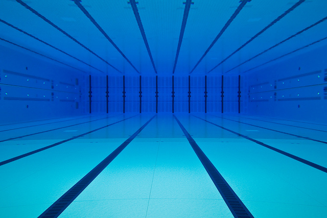
- Thus, the Columbia River dumps the equivalent of about three Olympic-size swimming pools of water into the Pacific Ocean every second. That is about 168 pools per minute or over 10,000 Olympic-size pools of water per hour! Keep in mind that that is 24 hours a day and 365 days per year.
- Finally, notice that the Columbia has by no means the largest discharge rate of the selected rivers shown on this slide. The Mississippi River, for example, discharges over twice this volume of water per second into the Gulf of Mexico.
- In summary, students should recognize that watersheds are very dynamic systems that handle incredibly larges volumes of water on a continuous basis. They are the sites of both natural and human activity.