Teacher Portal
Atmosphere
Deep Analysis
Deep Analysis
Atmosphere

Deep Analysis
Use the questions below to go deeper into the scientific concepts and applications of each Investigation. Note that questions highlighted in orange text are also featured in Phase 3.1 (Conclusions) of the Student Guide PDF.
Investigation 1
- Think about the changes in density observed as the air in the flask was heated and cooled. How could the changes in density be used to explain why the colder air was found below the warmer air in the experiments with the ice cube and metal cube? As the temperature of air increases (air is heated) it expands and the volume it occupies increases. However its mass does not change. The result is a decrease in its density. As the temperature of air decreases, (air is cooled) it contracts and the volume it occupies decreases. However its mass does not change. The result is an increase in its density. Air is a fluid. Fluids of lesser densities float or are found above fluids of greater densities. Therefore, cooler air that is more dense would be found below warmer air that is less dense.
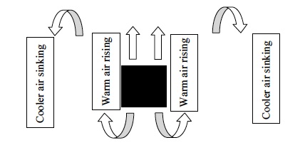
- How did the air move around the metal cube? The air around the metal cube was heated by heat transfer from the metal cube, it became less dense and began to rise above the cooler, more dense air around it. The warmer air rose above the metal cube. As the warmer air rose, a vacuum was created and cooler, less dense moved to fill the area. As the cooler, less dense air moved below the metal cube, it was heated and rose. The result was a continuing convection current. As a result, the air became warmer above the metal cube and cooler beneath the metal cube.
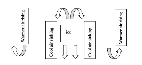
- How did the air move around the ice pack? The air around the ice pack was cooled as heat was transferred from the air surrounding the ice cube to the ice pack. As heat was transferred from the surrounding air the air was cooled and it became more dense. The less dense air began to sink below the warmer air next to it. As the cooler air sank, warmer air moved to fill the area. As the warmer air moved above the ice pack it was cooled and began to sink. The result was a continuing convection current. As a result the air became cooler below the ice pack and warmer above it.
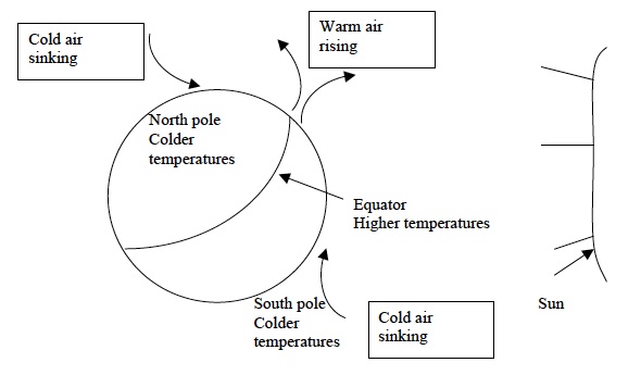
- Imagine that the metal cube was a model of the land found at the Equator and the ice pack was a model of the land found around the north and south poles. Look at the picture of the Earth below. How would the air move around the Earth?Students should suggest that the warm air from the equator would rise toward the poles and that the cold air from the poles would sink towards the equator.
Investigation 2
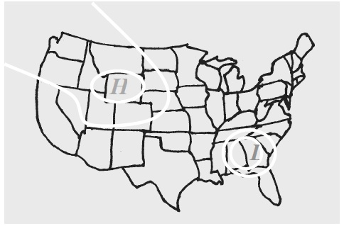
- The weather map below shows areas of high and low pressure. Describe what is happening to the air at each of these locations. There is a high-pressure area over Oregon and a low-pressure area over Georgia. Air from the upper levels of the atmosphere over Oregon moves toward the surface of the Earth. As a result, the pressure below the downward-moving air is higher than the surrounding areas. Air from the lower levels of the atmosphere over Georgia is rising. As a result, the pressure below the rising air is lower than the surrounding areas.
- In Investigation One you learned that cold air sinks and warm air rises. What type of pressure center would develop in an area in which a large amount of warm air is rising? Why? Low-pressure centers occur when the upward force of moving air and air molecules is greater than the downward force of moving air and air molecules. Therefore, a low-pressure center develops directly below rising air. The warm air that is rising would cause a low-pressure center to develop.
- What type of pressure center would develop in an area in which a large amount of cold air is sinking? Why? High-pressure centers occur when the downward force of moving air and air molecules is greater than the upward force of moving air and air molecules. Therefore, a high-pressure center develops directly below sinking air. The cold air that is sinking would cause a high-pressure center to develop.
- In which direction did the aluminum foil pieces move when the high-pressure center was surrounded by areas of lower pressure? Explain your answer in terms of pressure differences. The aluminum foil pieces moved from the area of high pressure outward toward the areas of lower pressure.
- In which direction did the aluminum foil pieces move when the low-pressure center was surrounded by areas of higher pressure? Explain your answer in terms of pressure differences. The aluminum foil pieces moved from the areas of high pressure to the areas of low pressure.
- Wind is the horizontal movement of air between areas of different pressures. In which direction does the wind blow? Explain your answer in terms of differences in pressure using data from your experiment. When a high-pressure center was created by lowering the stack of paper and pushing air in a downward direction, the air moved from the area of higher pressure outward toward the surrounding areas that were lower in pressure. This was observed as the aluminum foil pieces moved outward from the “high-pressure center.” When a low-pressure center was created by lifting the stack of paper and pulling air in an upward direction, the air moved from the surrounding areas of higher pressure toward the area of lower pressure. This was observed as the aluminum foil pieces moved inward toward the “low-pressure center.”
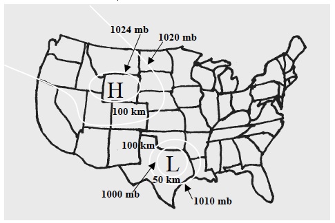
- How did the strength of the wind change as the distance between two areas of pressure increased? The aluminum foil piece moved 17.6 cm when the distance between the 1020 mb area and 1000 mb area was 20 km. As the distance between the 1020 mb high-pressure center and 1000 mb low areas increased to 140 km and 260 km, the foil pieces did not move as far: 8.8 cm at the 140 km isobar and 0.7 cm at the 260 km isobar. A similar result was observed when the distance between the 1020 mb high-pressure areas and the 1000 mb low-pressure center was increased. The foil piece moved 18.6 cm when the distance between the 1000 mb and 1010 mb areas was 20 km but only 2.7 cm and 0 cm when the distance was increased to 80 km and 140 km. Therefore, the strength of the wind decreased as the distance between the areas of high and low pressure increased.
- The map below shows different isobars of pressure across the United States. Determine the pressure gradient force for the winds that will occur. Use the pressure gradient force to describe the strength and directions of the winds that will occur. Winds will blow from the 1024mb center of the high-pressure center toward the 1020mb area. The pressure gradient force will be 4mb/100km. Winds will blow from the 1020 mb area towards the 1010 mb area. The pressure gradient force will be 10mb/100km. Winds will blow from the 1010 mb area toward the center of the low-pressure center (1000mb). The pressure gradient force will be 10 mb/50 km. The strongest wind will be towards the low-pressure center (10 mb/km). The weakest wind will be outward from the high-pressure center (4 mb/100 km.
- In which direction did the water in the barometer move when an area of high pressure was modeled? The water moved up into the test tube.
- In which direction did the water in the barometer move when an area of low pressure was modeled? The water moved from higher up in the test tube to lower in the test tube.
- “The barometer is falling” is one phrase used to forecast weather changes. What does this phrase indicate about the change in pressure that will occur over an area? This would indicate that an area of low pressure is developing over an area. The observations made in this experiment showed that the level of water in the barometer fell when an area of low pressure was modeled.
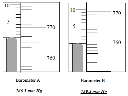
- Two barometers are shown below. What is the barometric pressure of each? Which shows a higher atmospheric pressure? Barometer A shows the higher atmospheric pressure.
Investigation 3
- Why did water form in the tube that was placed between the sides of the ice water bag? Why did water appear in the centrifuge tube? Explain your answer in terms of the temperatures of the air in the flask and in the tube. The air that rose from the heated flask was moist and very warm. The molecules of water in this air possessed a great amount of kinetic energy. As the heated air rose, it encountered air in the tube that was surrounded by the ice water. The air in this tube was cooler than the air from the flask. As the temperature decreased the kinetic energy of the water molecules decreased. As a result there was condensation of some of the molecules of water vapor.
- In the model, the moist air mass was represented by the water vapor that rose up into the flask and the tubing. The cold upper atmosphere was represented by the tubing inside the bag with ice water. How does your experiment help explain why precipitation occurs at a front? The experiment showed that if warm moist air rises into the upper layers of the atmosphere where the temperature is colder than the temperature of the air in the warm moist air mass, the water vapor contained in the warm moist air mass will condense and precipitation can occur, falling to Earth.
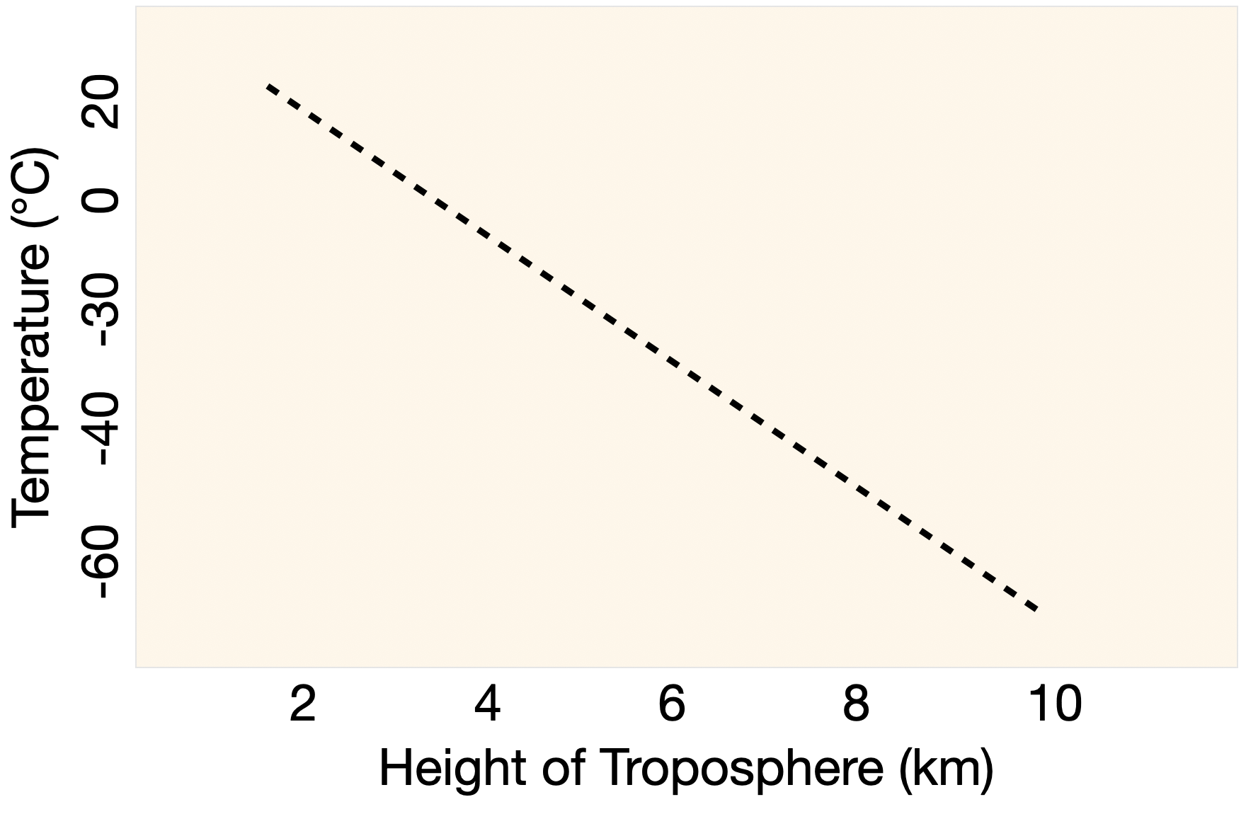
- The diagram below shows the relationship between altitude and the temperature in the troposphere. Which part of the model does the diagram resemble? In the model this is represented by the tubing that is between the sides of the bag containing ice water.
How do differences in the density of air contribute to the formation of fronts? Air masses of different temperatures have different densities. Warmer air is less dense than colder air. When air masses of different temperatures collide, their differences in density result in the warmer air mass rising over the colder air mass. As the warmer air mass rises into the colder, upper levels of the atmosphere the rates of evaporation and condensation of the water and water vapor in the air mass change because of the temperature change. As the temperature of the air decreases, the kinetic energy of the gas molecules that comprise air decreases. The result is that the rate of condensation becomes greater than the rate of evaporation and cloud formation and precipitation can occur. The amount of condensation and precipitation that occur then depends upon the humidity or amount of water vapor contained in the air mass.
Comprehension Check
- What happens to air as it is heated and cooled? The volume and density of air change with temperature changes. As the temperature of air increases, its volume increases, and its density decreases. As the temperature of air decreases, its volume decreases, and its density increases.
- How do changes in the temperature of air affect its density? As air is heated its density decreases because its mass remains constant but its volume increases. As air is cooled, its density increases because its mass remains constant but its volume decreases.
- Why do changes in density cause air movement? Air is a fluid. Fluids that are more dense sink below those that are less dense. The decrease in density as air is heated causes it to rise above cooler, more dense air. The increase in density as air is cooled causes it to sink below warmer, less dense air.
- How do differences in the temperature of the Earth’s atmosphere affect the movement of air? The warmer air in the atmosphere rises and cooler air in the atmosphere sinks. This causes convection currents in the atmosphere.
- What types of air movements cause areas of high and low pressure? Air that moves from the upper levels of the atmosphere downward towards Earth creates an area of high pressure beneath the falling air. Air that rises or moves upward from the Earth or from lower levels of the atmosphere toward the upper atmosphere creates an area of low pressure beneath the rising air. Cold air sinking would increase the pressure in an area while warm air rising would decrease the pressure in an area.
- Why do differences in pressure cause wind? When there are pressure differences in the atmosphere air moves from areas of high pressure to areas of low pressure. This movement of air creates wind.
- How are differences in pressure measured? Changes in pressure are measured with a barometer. One type of barometer is the mercury barometer. As the pressure of an area increases the increased downward force of air pushes the mercury in a barometer up into the barometer. As the pressure of an area decreases, the level of mercury in a barometer falls because the downward force of air on the liquid in the barometer has decreased.
- What changes in temperature are necessary for precipitation to form along fronts? The temperature of the atmosphere decreases with the height of the atmosphere. Areas of the atmosphere closer to the ground have a higher temperature than areas higher in the atmosphere. When cold fronts form, air from the cold and warm air masses move as a result of their densities. The more dense cold air pushes under the less dense warm air ahead of it. The air in the warm air mass rises. As the warm air rises, it encounters cooler temperatures, and the rate of evaporation decreases. As the rate of evaporation becomes slower than the rate of condensation, water vapor in the warmer air condenses and forms clouds and precipitation. When warm fronts form, air from the cold and warm air masses move as a result of their densities. The less-dense warm air behind the colder air masses rises and slides over and above the cold air mass. As the warm air rises, it encounters cooler temperatures, and the rate of evaporation decreases. As the rate of evaporation becomes slower than the rate of condensation, water vapor in the warmer air condenses and forms clouds and precipitation.
- What changes in atmospheric pressure occur with the passing of a cold or warm front? In both cold and warm fronts, the rising of the warmer air mass is accompanied by a decrease in the atmospheric pressure. In a cold front, there is a decrease in pressure as the front forms because the cool air mass slides under the warmer air mass and pushes it upwards. The rising warm air results in a decrease in atmospheric pressure. This decrease is followed by an increase in pressure once the front has passed because of the cooler sinking air that moved in behind the warmer rising air. In a warm front, there is a decline in the atmospheric pressure as the front moves into an area because a warm air mass moves in behind a cooler air mass. As the warm air mass slides over the cooler air mass there is a decrease in pressure. The pressure continues to drop as the front passes because of the warmer, rising air that moves in behind the cooler air mass.